Day 65: Selden Pass and Bear Creek

Date: July 3, 2017
Miles: 17.6 miles (28.3km), from mile 855.9 over Selden Pass to mile 873.5.
Health: Feeling great. Legs little tired from the long day yesterday.
I woke up at 4:30am after snoozing the alarm for half an hour. No one else was up yet. I switched my headlamp to the red light mode not to wake anyone and quietly started putting my things together.
I was ready little later but ate a quick breakfast at the camp and stretched my legs. My legs are little tired but not as much as I would've thought after all the miles, climbing, and snow yesterday.
As I start hiking I see the others waking up. I cross the river over the bridge and decide not to fill up my water bottles as the river is raging so badly that I don't want to get anywhere near it. There's another stream coming up soon I'm sure.

The river I didn't want to get water from.
I'm little too far from the Selden Pass so I'm trying to rush a little as I want to get there as soon as possible. The snow usually gets really slushy and hard to walk on after 10am. Before I can reach the pass I have to climb over 3,300 feet (1,005m) of elevation in about 8 miles (12.9km).
I estimate I'm going to reach the pass at around 11:30am or at noon. That means, depending on how large the snowfields are before the pass, that I'm going to do all the snow walking in the slush. Thankfully this pass is lower in elevation than the others we've crossed, so hopefully the snow isn't going to be bad.
First few miles are pretty gradual climb but I can't find a water source anywhere. I'm already little thirsty. Apparently this is the only section so far in the Sierra with no streams crossing the trail all the time. As I climb more I cross few mud puddles, but I'm not that thirsty yet.

After two hours of climbing I finally reach a small stream crossing the trail. I fill my water bottle and camel up a liter. I also take out an extra Snickers bar as I'm still hungry.
Soon the climb starts to get steeper and I hit the switchbacks. It's so nice to climb up on switchbacks instead of on snow. At one point I notice two of the hikers from the camp behind me. They're fast and seem to be rushing all the time. Not my style of hiking but HYOH.
After couple of switchbacks they catch up and I give them room to pass. Not much is said. I miss our bubble. Sierra really messed up everything. Our tramily is all over the place, and our awesome bubble is also broken. Some people skipped Sierra, some flipped, some quit, and the rest who are on trail, are all spread out on such a large area that I won't see anyone before Mammoth.

Sunshine, Dandelion, and Fireant are pushing to make it to Mammoth by 4th (Independence Day), Otter and her group are somewhere way ahead, Pony and her group are a day or two behind, and Topo and DG are one Pass behind.
I was originally planning to go directly to Mammoth, but I'm running out of electricity and food. My battery pack won't be enough for an eight day section, and my food selection is very limited. I only have one more dinner left, everything else is just snacks.
I hike past the junction to Muir Trail Ranch but it's too early to go in. And as they don't have electricity, they could only help me with food. Although there are not that many JMT hikers out yet, so the hiker boxes might be empty this early in the season. But I could make it to Vermilion Valley Resort (VVR) by tomorrow morning. It's a $23 ferry ride back and forth but there I could get a good meal, do a small resupply to last me to the next town, and recharge my electronics. The critical ones are my phone (maps and GPS) and my InReach.
As I climb the switchbacks I send my mom a message on InReach that I will run out of battery by today or maybe tomorrow. Just to let them know that I'm ok and that when the satellite tracker disappears, not to worry.
I eat another Clif bar and read the notes on VVR on Guthooks. Someone had a pulled pork sandwich there. Right now, eating nothing but bars, that sounds so good. I could possibly push three big days to Mammoth and risk doing the last pass and miles without the GPS, or I could go to VVR, eat well, charge my devices and still make it to Mammoth in three days. I decide to go to VVR.
I reach 10,000 feet elevation. The snow should start soon but beside few lonely snowbanks here and there, I don't see any.

Sometimes the trail is a little moist.
Soon I catch up to the two hikers who passed me earlier and find them sitting by a river, eating snacks. I would have crossed the river first and then taken a break but, HYOH. They look like they're just quietly eating, no talking or anything. Breaks were the moments when our tramily was the loudest. I can't remember a single instance when we've sat and not spoke at all.
I cross the river little downstream where it splits into three smaller streams. The first two I cross over logs but have to wade through the third. After shaking some of the water out of my shoes I continue climbing.
The trail continues in a forrest and there's not much to see. I put on both of my headphones and start rocking to Metallica's live recording of One. I'm all in my own world, doing air guitar with my pole, strumming air, and head banging, when I hear a noise behind me. I turn around and it's the two hikers. I step aside and they pass me, smiling a little. I'm glad I wasn't singing.

My little break by the lake.
Soon the climbing stops and we reach a plateau. I catch up to the two hikers and we cross a lake outlet together. I'm hungry and the lake looks awesome so I stop to dry my socks and to eat by the lake.
I spend half an hour just sitting there, alone, watching the mountains and the lake. What a beautiful sight. Then I must move again as the snow is melting.
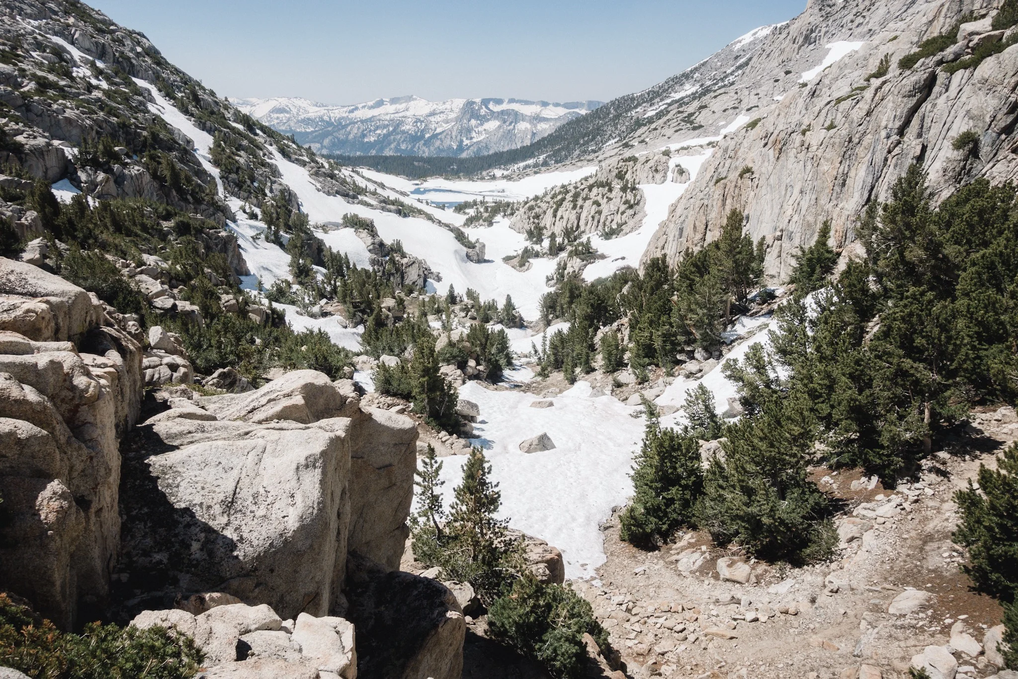
I'm only 1.6 miles from the pass and there's no snow yet. So far this seems like an easy pass to cross. I ford one more river and then the snow starts. But I can already see the pass.

Selden Pass from where the snow starts.
I climb the last 900 feet of elevation and reach the pass. Well this was uneventful. There was about a mile of snowfields before the pass, meaning this was by far the easiest pass we've done so far.
I take one photo from the top and then start climbing down wondering how far the snowfields reach on the north side. I look at my clock and I was at the top an hour before I estimated. Not bad, considering I took an half an hour break.
Looking back from the top.
The climb down is as uneventful as the climb up. The snow is slushy but nothing we haven't already seen. The snowfields reach about 2 miles down from the pass and then end. This was a really easy pass.
As soon as the snow ends I reach one of the forks of Bear Creek. Bear Creek is one of the two notorious crossings on PCT (Evolution Creek being the second, which we did yesterday) and it is bad on a regular or a low snow year. This year is a record snow year so it's going to be interesting to see what it looks like.
I cross the stream and water comes up to my waist and the current is quite strong. And this is only one of the forks and tributaries that feed into the main river I soon have to cross.
I curse that I wasn't able to keep up with the other two hikers as it would be really helpful to have someone there as I'm crossing the river. I'm approaching the river crossing alone, knowing there's no one there and knowing there's no one behind me for at least a day.
I hike the mile down to the Bear Creek and I can hear the water rushing from far away. I try to look at the river from upstream as much as i can but it seems impassable. I could go even more upstream and cross the river from where it splits into three parts, but the terrain doesn't look good for bushwhacking. It's too rocky and I might be able to make my way up there.
I'm betting my changes of getting across on the rumor that a tree had fallen on the creek a little downstream from the PCT crossing. I don't know if the tree crosses the whole stream, or if it's still there.
I get to the PCT crossing and it looks bad. The water is at least chest deep and rushing fast. There's no way I can make it across from here. There's a mark on the ground that says LOG and an arrow pointing downstream.

The fallen tree across part of the Bear Creek.
I hike about 0.3 miles downstream and where the creek splits in two, with an island in the middle, I see a large tree fallen on the creek on other side of the island. This must be the spot. I wade in knee deep water to the island and check out the tree.

Sometimes the trail is also a creek.
The large trunk almost reaches the island and someone has placed a smaller log to reach the fallen tree. I don't like logs and being alone, falling under the tree and the branches, with the heavy flow, would be a very bad mistake. I put down my pack and go through my options.
I notice that the tree pushes the flow of the river towards the other side and leaves a shallow spot in the middle, from where I could reach the trunk without going over the sketchy spot with the heavy flow.

More streams crossing the trail. And fallen trees.
I secure all my electronics in the waterproof bags, just in case, and hop in to the water. It's mostly only shin deep and gets a little deeper as I reach the trunk. I'm careful not to get into a spot where I could get swept under the tree by the water. I easily climb on the trunk and walk to the other side. Phew.
That was way easier than I thought. Although it was not smart to do this crossing alone, this was fairly easy and I was at no point in any kind of danger. I was mentally prepared to camp here, if the crossing looked bad, to wait for the others to arrive but this time I didn't have to do it. As a rule of thumb, never cross rivers alone.

I quickly rejoin the trail, dry my shoes a little and continue hiking. Only one more pass before Mammoth and all the "scary" stuff is behind me now.
As I hike on, I keep cursing the bear canister. It has been sticking at my back ever since I got it and it's starting to really hurt. It's like having a large, circular object poking at your back at every step. Ugh. I'm so happy to get rid of it in few weeks. I try to repack my pack to get the bear can to a different spot but to no avail. The joys of frameless packs.
Looking at the map I'm less than 8 miles from the junction to VVR. There's an 1,000 feet climb between me and the junction. I don't need to walk all the way to the junction today and Guthooks is telling me all the camping spots are on this side of the climb. The other side looks like nothing but switchbacks so I doubt there's any place to camp there.

The view from my shelter.
I climb about half the way, while crossing multiple streams going over the trail, and then find this gorgeous spot with place just for few tents. And no one's here. It's early but I've already done over 17 miles and it doesn't make much sense to push further if there are no camping spots on the climb down. I decide to stay here and call it an early day.
I set up my tarp, eat, watch the mountains, and listen to the creek next to my shelter. It's so beautiful and peaceful out here.
I'm so in love with Sierra, even though it's kicking my butt daily. I feel like not a single photograph I could take, or a sentence I could write, could ever do justice to the beauty of this magnificent place. I feel such an inner peace and happiness here among the mountains. I feel like I'm at home. Sierra has completely stolen my heart.

I sit alone on a fallen tree trunk, contemplating on how I'm so lucky to be out here, eating cold soaked ramen, drinking cold hot chocolate, while watching the valley down below. All this to myself. And then I realize, this is the first time on the trail that I'm camping all by myself. It took over two months and 800 miles but I'm finally camping alone. And what a spot!
I go to bed early while listening to the sound of the creek. Tomorrow I'll get to VVR and get some real food! And then Mammoth in three days!
Sponsored by:
![]()