So, I’m hiking the Pacific Crest Trail this summer

There, I can say it out loud: I’m hiking the Pacific Crest Trail this summer. It’s been a bumpy 5 months of organizing, but I finally have all my permits in check, flights booked, work sorted out, apartment packed up with all my stuff in boxes, and I'm ready to head out to the trail.
I’ve planned for this for the past 1,5 years and on 25th of April, I’m flying from Helsinki to San Diego where I'm staying for a few days with a good friend of mine. And if everything goes well, I'll be standing on the southern terminus of the PCT in Campo, California, on the 30th of April, ready to take my first steps along the 2,659 mile long trail – hoping my feet will carry me all the way to Manning Park, Canada.
What is this Pacific Crest Trail?
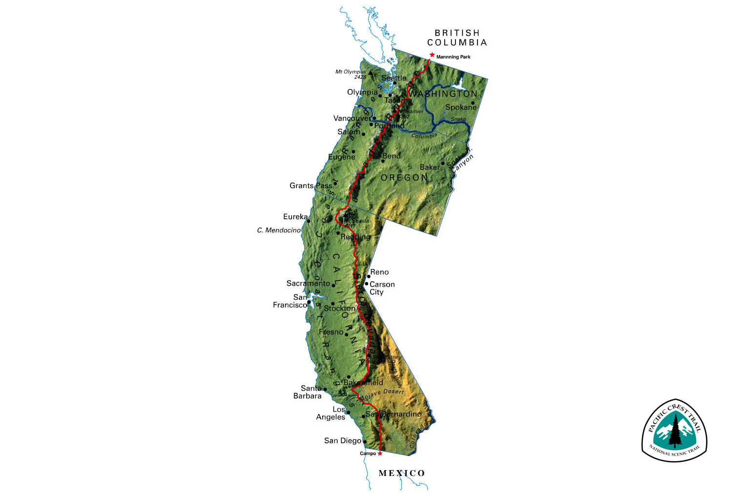
The Pacific Crest Trail (commonly abbreviated as the PCT) is a long-distance hiking trail located on the U.S. west coast. The trail starts on the U.S.–Mexico border, just south of Campo, California, and ends on the U.S.–Canada border, on the edge of Manning Park in British Columbia.
The 2,659 mile/4,279 km long PCT corridor spans through California, Oregon, and Washington, passing through 26 national forests, 7 national parks, 48 wilderness areas, 5 State Parks, and 4 National Monuments. The trail closely aligns with the highest portion of the Sierra Nevada and Cascade mountain ranges, and ranges in elevation from just above sea level at the Oregon–Washington border, to 13,153 feet (4,009 m) at Forester Pass in the Sierra Nevada.
Usually, the PCT is hiked from the southern terminus in Campo, to the northern terminus in Manning Park. For most thru-hikers hiking through the PCT takes about 5-6 months. Those that complete the thru-hike have climbed up 428,011 feet (130,458m) and descended 426,486 feet (129,993m) – that is the equivalent of almost 15 ascents and descents of Mt. Everest from sea level.
PCT sections

The PCT is typically divided into 5 sections:
- Southern California: some nice higher mountains, mostly dry desert mountains, some flat desert areas, some really hot places (Mojave Desert).
- Sierras: gigantic granite mountains carved by glaciers, snow, no roads, huge glacial valleys, lots of mosquitoes, bears.
- Northern California: less dramatic mountains (except for Mt. Shasta), lots of massive river valleys to climb in and out of, fewer mosquitoes. Transitions into the Cascade Range (i.e. volcanoes).
- Oregon: mostly flatter trails, lots of lakes, lots of mosquitoes, larger volcanoes.
- Washington: lots of climbing, massive mountains, gorgeous views.
Timing
Due to the terrain, seasonal weather patterns, and the length of the trail, there’s only a short window for northbound thru-hikers to start their hike. They need to start their hike early enough to make it out of the desert before it gets too hot, get to the Sierra late enough for the snow to have melted for the high mountain passes to be passable and still have enough time to make it to the northern terminus before the on-coming winter. During a regular year, this means that most hikers start from the middle of April to early May and aim to get to Sierra by June 15th.
Southbound thru-hikers start a month or two later. They can start once the high mountain passes in Washington are safe to pass through.
Most common questions and answers

The more I talk to people about the trail, the more I find myself answering a lot of similar questions. To help out a little, here are some of the most commonly asked questions and answers to them. If I didn’t answer some question, please ask me in the comments and I’ll update this list.
Are there any [insert dangerous animal] there?
In the desert, you will meet rattlesnakes, scorpions, spiders and other desert critters. All of them want nothing to do with you. Having your ears and eyes open and being extra careful around dusk and you can avoid any unpleasant confrontations with rattlesnakes.
Further up north, there will be black bears and mountain lions. Abiding by good bear etiquette (not leaving food around, using bear canisters, not getting between mommy and her cubs…) and traveling in groups when in mountain lion country is more than enough. If you'll see these animals, they are most likely running away from you. Fatal animal encounters along the PCT are almost non-existent.
Most animal problems I'll encounter will be caused by mice, marmots, dogs, cows, bees, ticks, and deer who like to eat the ends of hiking poles for the salt.
Are you going to carry a gun/bear spray?
While the bear spray is useful in brown bear country, black bears are more mellow and less aggressive and usually need just a little yelling to spook away. Also as far as I can tell, bear spray is illegal at least in Yosemite.
Gun? Hell no.
Are you afraid of [insert a fear here]?
I'm most certainly afraid, but usually, it's not by the things most people think. What I'm most afraid of are things like hypothermia, lightning, bees, giardia, river crossings, falling through a snow bridge, postholing endlessly in the Sierra snow, running out of water in the desert, and mostly, my body failing on me mid-hike.
How are you connecting with family/friends from the trail? Is there cell phone coverage?
My main contact with my family is going to be my DeLorme inReach satellite messenger. This way my parents can follow my hike using the satellite pings on a map and we can send messages through the satellite network. This will work anywhere with a clear view of the sky.
There’s also an S.O.S. button on the inReach that allows me to contact SAR if I, or any other hiker, needs to be rescued from the trail.
I'll also carry my iPhone and use it when there's coverage, meaning mainly close to trail towns and few others spots.
Are you going to carry all your food?/where do you get your food?/are you going to forage/hunt your own food?
I will be resupplying from small trail towns along the way and when there are no towns available, I'll send resupply drops or hitchhike to towns further from the trail. Generally, I will be resupplying every five to seven days, but my longest stretch between resupplies is 9 days.
Where are you going to sleep?
I carry my own shelter. Depending on the weather and bugs/crawlies, on most nights I will sleep in my shelter or cowboy camp (sleep on the ground). Sometimes I need to stay in trail towns and then I'll sleep in a hotel/hostel.
Is Fire coming with you?
Sadly I can't take Fire (my Australian Shepherd and hiking partner) with me. Instead, he's staying home in Finland with really awesome caregivers.
Why can't you take Fire with you?
For multiple reasons, but mostly logistics and his own safety and welfare. Along the PCT corridor, there are many areas where dogs are not allowed. Working around this as a non-US hiker would be a real headache.
Secondly, the food and water carriages would be too much. There are long waterless stretches on the trail and carrying his food and water would be too much.
Thirdly, I know him well enough to know that he wouldn't enjoy hiking for 20-30 miles per day for 5-6 months. And for a dog who doesn’t like heat, 800 miles/1,200 km of desert hiking is not the most inviting idea.
Are you going to keep a journal? Can I follow your hike?
I will be updating this blog as I go along, and also updating photos to my Instagram account.
Why are you doing this?
First and foremost, I love hiking. While I love sitting around the camp, by the fire, chilling, I actually like the hiking part more. And while there are some great trails in Finland and surrounding countries, I’ve always felt I wanted to do a longer trail. Hike longer days. Really push myself to the limit.
I originally wanted to do a longer hike in Europe, or in New Zealand, but the more I’ve hiked, the more I’ve learned what I like, and once I started studying the PCT, I immediately knew it was the trail I wanted to hike. I hate hiking in a “green tunnel” and love being high in the mountains and open vistas.
On a more personal level, this April marks the ten year anniversary of working in the advertising industry. For some time now, I’ve felt that I’ve been doing the same thing for too long, and felt like a little pause – taking some distance – would be a good thing. Is there anything better than spending 5 months in the wilderness, away from emails, meetings, and deadlines to charge one’s mental batteries?
Sponsored by:
![]()